


S. Austin Bicking Dam 1975
Federal Insurance Administration proposes Flood Control

In 1976, a flood study done in Downingtown by the US Department of Housing and Development Federal Insurance Administration set the stage for the federal definition of the Kardon Park Mill Race as a tributary of the Brandywine.
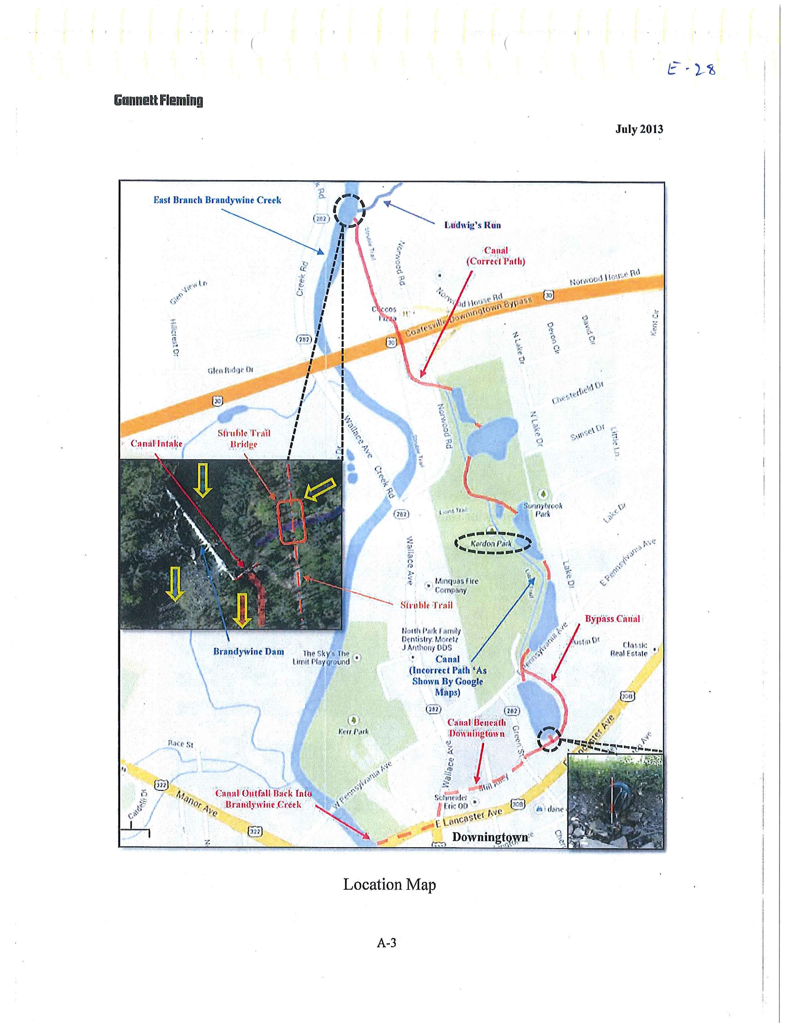
Page 4 (2.2) The borough is drained primarily by the east branch of the Brandywine Creek. Two major tributaries to the east branch are Beaver Creek and Park Run. A series of small shallow lakes are connected by an old millrace, which is essentially a branch of the east branch of the Brandywine Creek. The area around the lakes has been proposed for park use, although no construction has been initiated.
Page 5 (2.3) The largest flood on the east branch of the Brandywine Creek occurred in 1920, 1942, 1955, 1960, 1971, and 1972.
Page 6 (2.4) There are no major physical flood protection structures within the borough. However, various retention and storage basins are proposed for Park Run and the millrace area. Implementation of the proposed projects are dependent of the results of this study and the availability of community development funds.
Essential in any development plan is a document planning the activities. The Federal Insurance Administration was entrusted to HUD and HUD regulated programs for Flood Plain properties. This planning document led to an application for a community development block grant by the Borough of Downingtown.
The program Included:
Community Development Block Grant
Lakes Area Improvement $60,000
The Borough of Downingtown seeks to allocate a portion of the community development block grant funds to assist in financing of a project to eliminate ecological blight and develop a passive recreation on a twenty-five (25) site known as the “lakes area.” The project area is bounded by the Sunnybrook development on the east, Lancaster Avenue on the south by privately owned land on the west, Norwood Road on the Northeast, and Borough land on the north. The property is owned entirely by the borough but extends beyond the borough boundary on the north into East Caln Township. Within the project area, there are lakes, a small pond, and a millrace.
The project will be divided into phases. The first phase is the improvement of water quality and the general improvement of the ecological condition of the lakes. The second phase will be the development of amenities for passive and moderately active recreation activities.
Phase 1 – The following goals have been established
1. Maximize water circulation
2. Exclude stormwater runoff from the ponds
3. Preserve as much of the flowing stream as possible,
4. Design ponds with variable depths to provide variable habitats for fish and wildlife
The millrace feeds water into all but one of the lakes. The millrace itself is provided water by the east branch of the Brandywine Creek. The dam controls the water from the creek into the millrace through two gates. At present, only one gate is open and operable. One of the activities included in this project will be the repair of this gate.
To maintain a continuous flow through the lakes, portions of the millrace will be diverted into the lakes. Lake 4 will be fed by pipes through the dike that separates it from Lake 4B, a settling pond. Lakes 4B and 4A will be maintained as settling ponds to remove silt from stormwater entering the pond.
Variable habitats for aquatic life will be provided by dredging several of the lakes to different depths. Lake 4 which is presently 3 to 4 feet deep will be dredged to the depth of 7 – 10 feet. Lake 3 which is presently 2 feet deep will be dredged to a depth of 5 feet. Lake 2 will not be dredged but will be maintained at a depth of 2 feet.
It is estimated that approximately 31,000 cubic yards will be removed from the lakes. The dredged material will be used on site to provide fill for several low-lying swamp area to create “interesting earthforms.” The depositing of dredged material and all earth moving activities will be limited to preserve the natural character of the land. Natural drainage patterns will be maintained, and proper erosion and sediment control measures will be used in Phase 1.
The grant was secured, and the work was done. However, US Fish and Wildlife took exception to the “interesting earthforms” afterward and made the borough remove them.
Here is an example of how you cannot BS your way through the process. There is no official definition of “interesting earthforms”. If one seeks to be creative and invent something new, in many cases, the person reviewing your funding application must determine whether the concept is untried or the structure is questionable.
The concept of not filling in wetlands is pretty solid.
The Borough sought to connect all the lakes, have the mill race, and make the 100-year-old flood control system more permanent. Wings on the east side of the dam were opened during high water conditions in the Brandywine. About 100 of the borough's residents manually opened the wings and flooded Kardon Park, which had wetlands. The idea was that if everything were connected, it would be a good bypass for the town.